Update 7: Excavating a Roman kiln Read about a recent discovery of a Romano-British kiln on site at Wintringham.
What we see depends mainly on what we look for, Aston Recording is a very important part of our process.
Barrowing to the Bronze Age Our archaeologist Ollie provides an update on the Bronze Age findings at Hinxton.
Trackways to the past In the latest post from our team at Hinxton, they start to find answers to some of the questions we have about a major trackway across the site.
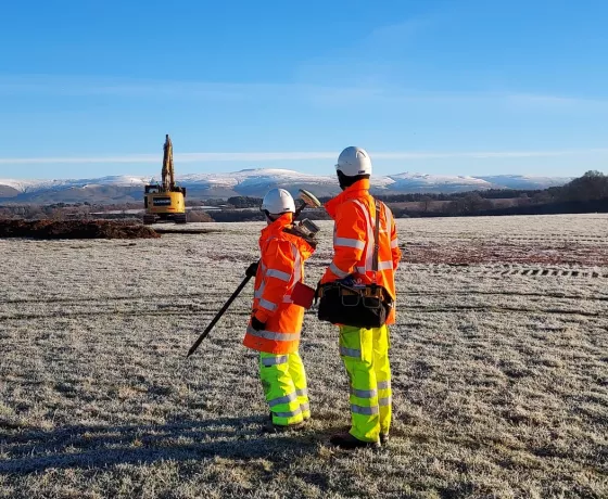
Update 8: Soggy Bottoms Read about the conditions the Wintringham team have been battling with as excavations come to a close for the winter.
End? No the journey doesn't end here... It is exciting to think about what will be discovered further.
Ring around the ro-undhouse Our archaeologist Anna provides a glimpse into what's been found of two Iron Age roundhouses near Grange Farm at Alconbury Weald.
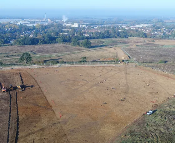
Update 9: The story so far... Read about some of the findings on Site 3 to date, as the team close down excavations over winter and start planning our return in March.
Buried beads Read more about some of the grave goods found by our Finds Supervisor Hannah Pighills from burial soil samples collected at Hinxton.
Weeley published in Current Archaeology OA has published an article about the excavation at Weeley in Current Archaeology magazine.
An unexpected (but welcome) surprise Area 7 appeared to be a quiet area in terms of archaeology. Turns out it was hiding something special...
In the Pits - Coming to the End of our Excavation At the end of March 2023, waterlogged and weary, but triumphal, the team concluded our excavations at Hinxton with a flurry of interesting finds at the heart of the site.
50 highlights for OA's 50th birthday In 2023 Oxford Archaeology is celebrating fifty years at the forefront of archaeological practice in the UK.
Our Research Work From the natural landscape of prehistoric Britain to First World War graves, our research into the past has a positive impact on the world today. See how our team contribute to national and international research.
Update 7: Excavating a Roman kiln Read about a recent discovery of a Romano-British kiln on site at Wintringham.
What we see depends mainly on what we look for, Aston Recording is a very important part of our process.
Barrowing to the Bronze Age Our archaeologist Ollie provides an update on the Bronze Age findings at Hinxton.
Trackways to the past In the latest post from our team at Hinxton, they start to find answers to some of the questions we have about a major trackway across the site.
Update 8: Soggy Bottoms Read about the conditions the Wintringham team have been battling with as excavations come to a close for the winter.
End? No the journey doesn't end here... It is exciting to think about what will be discovered further.
Ring around the ro-undhouse Our archaeologist Anna provides a glimpse into what's been found of two Iron Age roundhouses near Grange Farm at Alconbury Weald.
Update 9: The story so far... Read about some of the findings on Site 3 to date, as the team close down excavations over winter and start planning our return in March.
Buried beads Read more about some of the grave goods found by our Finds Supervisor Hannah Pighills from burial soil samples collected at Hinxton.
Weeley published in Current Archaeology OA has published an article about the excavation at Weeley in Current Archaeology magazine.
An unexpected (but welcome) surprise Area 7 appeared to be a quiet area in terms of archaeology. Turns out it was hiding something special...
In the Pits - Coming to the End of our Excavation At the end of March 2023, waterlogged and weary, but triumphal, the team concluded our excavations at Hinxton with a flurry of interesting finds at the heart of the site.
50 highlights for OA's 50th birthday In 2023 Oxford Archaeology is celebrating fifty years at the forefront of archaeological practice in the UK.
Our Research Work From the natural landscape of prehistoric Britain to First World War graves, our research into the past has a positive impact on the world today. See how our team contribute to national and international research.
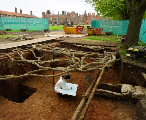
Breadcrumb Home News Our latest news The 44th Conference of the Association for Environmental Archaeology comes to Oxford Oxford Archaeology launches its Carbon Reduction Plan Oxford Archaeology contributes to pioneering new study from the Crick Institute that identifies genetic conditions from ancient DNA for the first time Oxford Archaeology works with the Forestry Commission on landmark Tree roots and archaeology project Our news Oxford Archaeology unveils new platform to explore the past Stainton West prehistoric site goes global OA and Cambridge Archaeological Unit work together to refit Early Neolithic pottery from causewayed enclosure in Harlow New branding for OA's 50th birthday Load More See our Project Feed Back to Homepage
Oxford Archaeology contributes to pioneering new study from the Crick Institute that identifies genetic conditions from ancient DNA for the first time
OA and Cambridge Archaeological Unit work together to refit Early Neolithic pottery from causewayed enclosure in Harlow